Back Illa de Lobos Catalan Lobos (pulo) CEB Lobos (ostrov) Czech Lobos (Insel) German Islote de Lobos (Canarias) Spanish Lobos Basque Isla de Lobos (Kanariansaaret) Finnish Los Lobos (îles Canaries) French Lobos FRR Illa de Lobos Galician
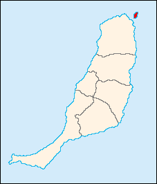
 Map of Fuerteventura showing Lobos | |
| Geography | |
|---|---|
| Archipelago | Canary Islands |
| Area | 4.68 km2 (1.81 sq mi) |
| Highest elevation | 127 m (417 ft) |
| Administration | |
| Autonomous Community | Canary Islands |
| Province | Las Palmas |
| Municipality | La Oliva |
| Demographics | |
| Population | 4 (2018) |
Lobos (Spanish: Isla de Lobos,[1] pronounced [ˈisla ðe ˈloβos]) is a small island of the Canary Islands (Spain) located just 2 kilometres (1 mile) north of the island of Fuerteventura. It belongs to the municipality of La Oliva on the island of Fuerteventura. It has an area of 4.68 square kilometres (1.8 sq mi). It has been a nature reserve (Parque Natural del Islote de Lobos) since 1982.[2][3]
The island is accessible to tourists via a short ferry ride from Corralejo, in the north of Fuerteventura. It has day facilities and weekend homes of local fishermen. It offers hiking and snorkelling tours. At the northeastern end of the island is the Punta Martiño Lighthouse, the lighthouse keeper and his family were the last permanent inhabitants of Lobos, until the light was automated in the 1960s.
In 1405, Lobos Island served as resupply base for Jean de Béthencourt's conquest of Fuerteventura.
- ^ Literally translating as "Wolves Island", the name refers to the Mediterranean monk seal, which was known locally as lobo marinero ("sea wolf", compare sea-"lion"). These animals are now extinct in the Canaries.
- ^ "Protected Natural Areas". Archived from the original on 2017-05-15. Retrieved 2014-04-24.
- ^ Boletín Oficial de Canarias, pages 9715 and 9851-2
